
Map of The Wild Center
- Sep 12, 2025
- 2 min read
Illustrated Trail and Exhibit Map for an Interactive Nature Center Experience
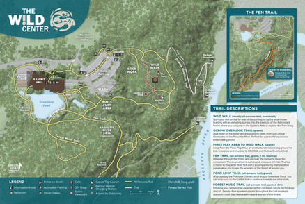
Green Goat Maps collaborated with The Wild Center to develop a foundational map system that supports the Center's mission of connecting people with nature through exhibits, trails, and seasonal attractions. This project focused on creating a base map for immediate use, while allowing for future layers of interpretive storytelling and map design enhancements.

To meet The Wild Center's needs, Green Goat Maps was contracted to:
Create a detailed base map of the campus, trails, infrastructure, and seasonal exhibits.
Incorporate trail data, buildings, protected land, waterways, and key points of interest.
Include an inset locator map for orientation and visitor navigation.
Prepare illustrations and visual enhancements in Phase 2, including trees, trails, rolling ball structures, and building depictions.
Coordinate design for kiosk-ready panels and brochure-compatible versions.
Green Goat Maps delivered a comprehensive basemap that includes multi-use trails, waterways, infrastructure, and all major exhibits. The design incorporates inset maps, protected lands, and trail markers. Future phases include detailed illustrations, interpretive elements, and design for various formats including kiosks and web display. All cartography was formatted for both printed and digital outputs to serve evolving communication needs.


Challenges of This Project
One challenge was building a map that would remain useful across seasonal changes in exhibits. With new trails and exhibits under construction, the base map needed to be flexible, georeferenced, and scalable. Balancing aesthetic goals with accuracy and future adaptability required close collaboration with the Center's team.
Value for Our Client
The Wild Center now has a professional-grade basemap that allows them to orient visitors, support interpretive storytelling, and showcase the growth of the facility. The map can be reproduced, updated, and expanded, making it a strategic communication tool for both internal planning and public engagement.
Green Goat Maps delivers cartographic and interpretive tools that evolve with the places they represent. Our tailored solutions support educational missions, recreation planning, and dynamic land management needs.
The new map is already being used in planning signage, brochures, and future visitor materials. With the base map in place, The Wild Center is poised to enhance its trail communications and exhibit storytelling across seasons, creating a more accessible and engaging visitor experience.
Interested in a Similar Project?
Let Green Goat Maps help you bring clarity and creativity to your outdoor spaces. Contact us to learn more about maps, kiosks, and custom cartographic services.


Comments